1/48
Locus GIS - land survey, data collection, SHP edit screenshot 0
Locus GIS - land survey, data collection, SHP edit screenshot 1
Locus GIS - land survey, data collection, SHP edit screenshot 2
Locus GIS - land survey, data collection, SHP edit screenshot 3
Locus GIS - land survey, data collection, SHP edit screenshot 4
Locus GIS - land survey, data collection, SHP edit screenshot 5
Locus GIS - land survey, data collection, SHP edit screenshot 6
Locus GIS - land survey, data collection, SHP edit screenshot 7
Locus GIS - land survey, data collection, SHP edit screenshot 8
Locus GIS - land survey, data collection, SHP edit screenshot 9
Locus GIS - land survey, data collection, SHP edit screenshot 10
Locus GIS - land survey, data collection, SHP edit screenshot 11
Locus GIS - land survey, data collection, SHP edit screenshot 12
Locus GIS - land survey, data collection, SHP edit screenshot 13
Locus GIS - land survey, data collection, SHP edit screenshot 14
Locus GIS - land survey, data collection, SHP edit screenshot 15
Locus GIS - land survey, data collection, SHP edit screenshot 16
Locus GIS - land survey, data collection, SHP edit screenshot 17
Locus GIS - land survey, data collection, SHP edit screenshot 18
Locus GIS - land survey, data collection, SHP edit screenshot 19
Locus GIS - land survey, data collection, SHP edit screenshot 20
Locus GIS - land survey, data collection, SHP edit screenshot 21
Locus GIS - land survey, data collection, SHP edit screenshot 22
Locus GIS - land survey, data collection, SHP edit screenshot 23
Locus GIS - land survey, data collection, SHP edit screenshot 24
Locus GIS - land survey, data collection, SHP edit screenshot 25
Locus GIS - land survey, data collection, SHP edit screenshot 26
Locus GIS - land survey, data collection, SHP edit screenshot 27
Locus GIS - land survey, data collection, SHP edit screenshot 28
Locus GIS - land survey, data collection, SHP edit screenshot 29
Locus GIS - land survey, data collection, SHP edit screenshot 30
Locus GIS - land survey, data collection, SHP edit screenshot 31
Locus GIS - land survey, data collection, SHP edit screenshot 32
Locus GIS - land survey, data collection, SHP edit screenshot 33
Locus GIS - land survey, data collection, SHP edit screenshot 34
Locus GIS - land survey, data collection, SHP edit screenshot 35
Locus GIS - land survey, data collection, SHP edit screenshot 36
Locus GIS - land survey, data collection, SHP edit screenshot 37
Locus GIS - land survey, data collection, SHP edit screenshot 38
Locus GIS - land survey, data collection, SHP edit screenshot 39
Locus GIS - land survey, data collection, SHP edit screenshot 40
Locus GIS - land survey, data collection, SHP edit screenshot 41
Locus GIS - land survey, data collection, SHP edit screenshot 42
Locus GIS - land survey, data collection, SHP edit screenshot 43
Locus GIS - land survey, data collection, SHP edit screenshot 44
Locus GIS - land survey, data collection, SHP edit screenshot 45
Locus GIS - land survey, data collection, SHP edit screenshot 46
Locus GIS - land survey, data collection, SHP edit screenshot 47
Locus GIS - land survey, data collection, SHP edit Icon

Locus GIS - land survey, data collection, SHP edit

Asamm Software, s. r. o.
Trustable Ranking Iconموثوق
1K+التنزيلات
35.5MBالحجم
Android Version Icon5.1+
إصدار الأندرويد
1.21.5(21-02-2024)الإصدار الأخير
-
(0 المراجعات)
Age ratingPEGI-3
التفاصيلالمراجعاتالنُّسَخالمعلومات
1/48

وصف لـ Locus GIS - land survey, data collection, SHP edit

Professional GIS application for working with geodata in the field. It enables both data collection and viewing. All its features are available over a wide selection of the world's best online and offline maps.


Fieldwork

• collecting and updating field data

• saving points with current or arbitrary position

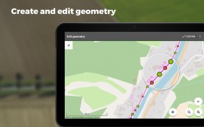
• creating lines and polygons by motion recording

• setting related data

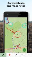
• photos, video / audio or drawings as attachments

• guidance to points


Import / Export

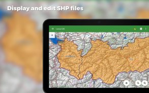
• importing and editing ESRI SHP files

• exporting data to ESRI SHP or CSV files

• exporting whole projects to QGIS
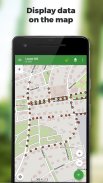
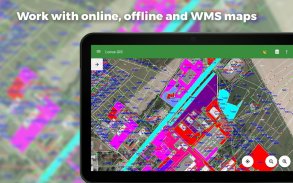

Maps

• wide range of online maps

• support of WMS map sources

• support of offline maps in MBTiles, SQLite, MapsForge, TAR, GEMF, RMAP formats and custom OpenStreetMap data or map themes


Other useful features

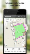
• measuring distances and areas

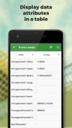
• searching and filtering of data in attribute table

• style editing and text labels

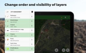
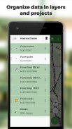
• organizing data into layers and projects

تطبيق نظم المعلومات الجغرافية المهنية للعمل مع البيانات الجغرافية في هذا المجال. أنها تمكن كل من جمع البيانات وعرضها. تتوفر جميع ميزاته عبر مجموعة واسعة من أفضل الخرائط على الإنترنت وغير المتصلة في العالم.


العمل الميداني

• جمع وتحديث البيانات الميدانية

• توفير نقاط مع الموقف الحالي أو التعسفي

• إنشاء خطوط ومضلعات عن طريق تسجيل الحركة

• إعداد البيانات ذات الصلة

• الصور والفيديو / الصوت أو الرسومات كمرفقات

• التوجيه إلى النقاط


استيراد / تصدير

• استيراد وتحرير ملفات ESRI SHP

• تصدير البيانات إلى ملفات ESRI SHP أو CSV

• تصدير مشاريع كاملة إلى QGIS


خرائط

• مجموعة واسعة من الخرائط على الانترنت

• دعم مصادر خريطة WMS

• دعم الخرائط دون اتصال بالإنترنت في MBTiles و SQLite و MapsForge و TAR و GEMF و RMAP وتنسيقات OpenStreetMap المخصصة للبيانات أو سمات الخريطة


ميزات مفيدة أخرى

• قياس المسافات والمساحات

• البحث وتصفية البيانات في جدول السمات

• تحرير نمط وتسميات النص

• تنظيم البيانات في طبقات والمشاريع


Locus GIS - land survey, data collection, SHP edit - إصدار 1.21.5

(21-02-2024)
نُسخ أخرى
ما الجديد*** 1.5.0 ***- add: new set of symbols for point layers (triangles, stars, crosses,...) - chg: improved management of WMS map layers- chg: the position of line labels- fix: defunct IGN WMS service

لا توجد آراء أو تقييمات بعد! لترك أول تقييم يرجى

-
0 Reviews
5
4
3
2
1
Info Trust Icon
تطبيق جيد نوصي بهلقد اجتاز هذا التطبيق اختبار الأمان من الفيروسات، البرمجيات الخبيثة أو أي هجمات خبيثة أخرى وهو لا يحتوي أي تهديد.

Locus GIS - land survey, data collection, SHP edit - معلومات APK

نُسخة APK: 1.21.5الحزمة: menion.android.locus.gis
التوافق مع أندرويد: 5.1+ (Lollipop)
المطور:Asamm Software, s. r. o.سياسة الخصوصية:http://docs.locusmap.eu/doku.php?id=manual:about:permissions&s[]=permissionsالأذونات:20
الاسم: Locus GIS - land survey, data collection, SHP editالحجم: 35.5 MBالتنزيلات: 691الإصدار : 1.21.5تاريخ الإصدار: 2024-04-03 03:47:16الشاشة: SMALLيدعم CPU نوع:
عنوان الحزمة: menion.android.locus.gisتوقيع SHA1: 1D:45:82:81:D6:0D:C1:32:23:AA:C0:F2:96:2E:57:3D:53:CD:7C:77المطور (CN): Menion Asammالمنظمة (O): محلي (L): Pragueالبلد (C): CSولاية/مدينة (ST): Czech Republic

آخر إصدار من Locus GIS - land survey, data collection, SHP edit

1.21.5Trust Icon Versions
21/2/2024
691 التنزيلات24 MB الحجم

نُسخ أخرى

1.21.4Trust Icon Versions
18/12/2023
691 التنزيلات24 MB الحجم
1.20.0Trust Icon Versions
7/6/2023
691 التنزيلات23 MB الحجم
1.19.3Trust Icon Versions
18/2/2023
691 التنزيلات23 MB الحجم
1.19.2Trust Icon Versions
23/12/2022
691 التنزيلات22 MB الحجم
1.19.1Trust Icon Versions
23/11/2022
691 التنزيلات22 MB الحجم
1.18.2Trust Icon Versions
29/8/2022
691 التنزيلات21.5 MB الحجم
1.18.1Trust Icon Versions
19/8/2022
691 التنزيلات21 MB الحجم
1.18.0Trust Icon Versions
10/8/2022
691 التنزيلات21 MB الحجم
1.17.0Trust Icon Versions
22/4/2022
691 التنزيلات18.5 MB الحجم

تطبيقات من الفئة نفسها

قد يعجبك أيضًا...